Britain Coast-To Coast, The UK’s Most Popular Thru-Hike or Cycle Route

Britain Coast To Coast – The UK’s Most Popular Long-Distance Walk
The British Coast to Coast (C2C) is a long-distance thru-hike across the breadth of England covering approximately 190 miles of the glorious British countryside. It starts on the west coast in the Lake District and crosses the Yorkshire Dales and Yorkshire Moors to finish on the east coast. Tradition states that you should dip your toe in the sea at one side and pick up a stone from the beach, then dip your toe in the sea when you finish and throw your stone into the ocean.
While the route was originally designed by Alfred Wainright, a famous British hill walker, most of the people who complete the Coast to Coast now do it on a bike via a new route for cyclists. The original hiking route links several dozen smaller trails together and is well maintained with lots of signposts along the way. It passes through 3 of England’s most beautiful national parks and has stunning views from start to finish.
The 190-mile walk takes anywhere from 8 – 15 days depending on fitness levels but there is no set time the hike must be completed in. Most people complete the hike in around 13 days which varies from lots of climbing to long and flat paths which go on for miles. As well as thru-hikers, there are many section hikers who cover the distance over many weeks or months and you will find people of all ages and nationalities who show interest.
You will need to prepare for the walk both physically and by making sure you have the correct outdoor gear. You can view my backpacking checklist which has some good info on what to pack. If you haven’t done anything like this before then you should know that having lightweight camping gear will make a big difference when walking such a long distance. A good backpack is also crucial as well as having appropriate clothing.
Day by Day Breakdown
*If you are camping wild on the first night, be sure to stock up on supplies in St. Bees as there are no little shops at your first stop in Ennerdale.
Wikimedia Commons by: Paul Buckingham
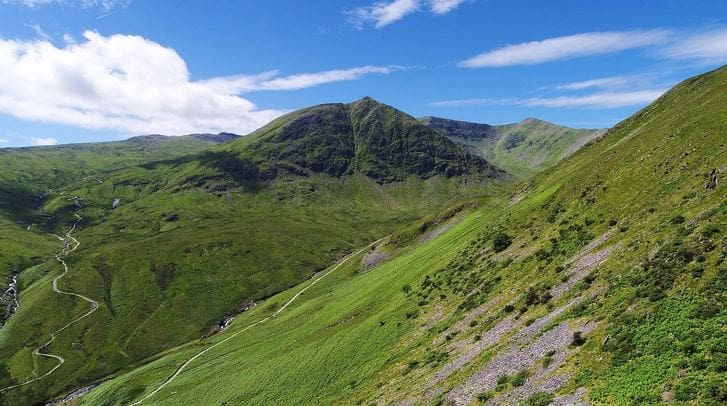
Day 1: St Bees to Ennerdale -14.5 miles / 23.5km: After dipping your toes in the sea and selecting a pebble to throw into the ocean on the other side of England, you walk along the coastline briefly before cutting inland. You are mainly walking across farmland constantly looking towards the mountains to come. As you enter Ennerdale it is easy to feel overwhelmed by the sheer beauty of the place. There is one pub and a few bed and breakfasts but accommodation is in limited supply. We opted to camp by Ennerdale Water which was picture perfect.
Day 2: Ennerdale to Rosthwaite – 16.5 miles / 26.5km: You start the day walking lakeside to the stunning Ennerdale Water which keeps you right on the water’s edge until you meet the river feeding it at the top. As you follow the river uphill you pass through sections of the forest all while slowly gaining elevation. The majestic Pillar mountain is on your right as you aim towards High Stile. If you are lucky you can stop at the legendary Black Sail Hut for refreshments before heading up High Stile. With the 2000 ft pass behind you, you gradually lose elevation as you pass by Honister Slate mine. You can end the day in Seatoller, Borrowdale, or Rosthwaite which all have some form of camping and accommodation. Again we chose to camp
Day 3: Rosthwaite to Grasmere – 8.5 miles / 13.5km: You begin the day walking along one of the streams that make up the River Derwent. There is a lot of strenuous uphill stretches and rugged terrain but nothing too difficult. You follow the Helm Cragg Ridge before heading down towards the lovely little town of Grassmere. This is a relatively short day hike but after carrying all your camping gear up and down over ridges, you will be ready to resupply or get a nice pub lunch.
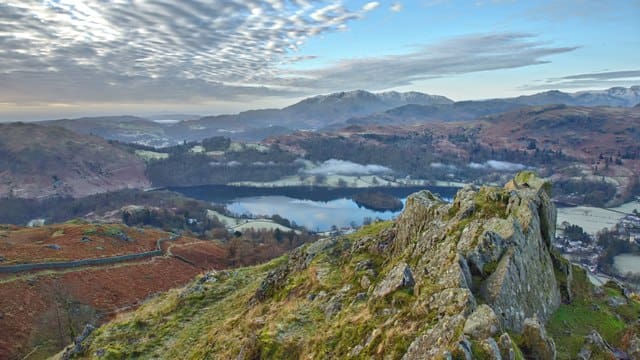
Image: Georgraph.org.uk by Mick Garratt
Day 4: Grasmere to Patterdale – 7.5 miles / 12km: Grassmere is where the poet William Wordsworth lived and wrote some of his most popular works. This is another steep and rocky trail that doesn’t look too far on paper but will take it out of your legs by the time you arrive in Patterdale. Views of Ullswater are stunning and worth taking in but if you are camping instead of staying in accommodation then you can carry on walking to make the next day a little easier.
Day 5: Patterdale to Shap – 16 miles / 26km: Day 5 feels like a long day and can be boggy depending on the weather but the stunning views of Yorkshire make up for it. The highlight of the day is the 12th Century Abbey which you pass before entering Shap, a quiet little village with a good pub and a few smaller shops. We got fish and chips then played in the pub poker tournament which didn’t go well but we met some locals and had a good time. The landlord allows you to sleep in the pub garden if you have a tent which makes it all too easy to drink until closing time.
Day 6: Shap to Kirkby Stephen – 20.5 miles / 33km: This is a very pleasurable section of the hike along grassy trails and through the great British countryside. This part of the hike leaves the Lake District in the distance as you prepare to enter the Yorkshire Dales and notice a change in the landscape. The mountains become less jagged and more like giant sloping hills with wide valleys. You will witness the limestone pavement of Westmorland and finish in the more built-up town of Kirkby Stephen which is a great place to stock up. We camped just before we got there to have a cooked breakfast the next day.
Image: Georgraph.org.uk by David Dixon
Day 7: Kirkby Stephen to Keld – 14.5 miles / 24km: After resupplying in Kirkby Stephen you leave the river Swale and head towards Nine Standards Rigg. There are 9 large rock sculptures at the top which give you a nice place to stop for a snack or some lunch if you packed sandwiches. The next section of the hike can be particularly boggy if it has rained recently but has the bonus of passing by Ravenseat farm which is run by the famous Yorkshire Shepherdess. Here you can get a mouth-watering cream tea which is scones with cream, jam, and a cup of tea (not to be missed). You then head down to link back to the River Swale before getting to Keld which is considered to be the unofficial halfway point.
Day 8: Keld to Reeth – 12.5 miles / 20km: There are two route options for this section, one is along the upper ridge and the other follows at the lower valley. Both upper and lower trails lead to Reeth and is a fairly easy day in comparison to some of the climbs in the Lake District. Reeth is a quaint village with a few bed and breakfasts, an ice cream parlor, and a village shop. The little village shops like the one in Reeth are small but incredibly equipped for resupplying.
Day 9: Reeth to Richmond – 12.5 miles / 20km: Another pleasurable day hiking through wooded hillsides and grassland with miles upon miles of dry stone walls built hundreds of years. Passing over remote pastures and hilly valleys you arrive in Richmond, a traditional Yorkshire Market Town. You can treat yourself to bakeries and a variety of shops including outdoor gear shops in case your boots are falling apart or you bent a tent pole. You can get an excellent pub meal or/and full English breakfast at the local pubs and cafes.
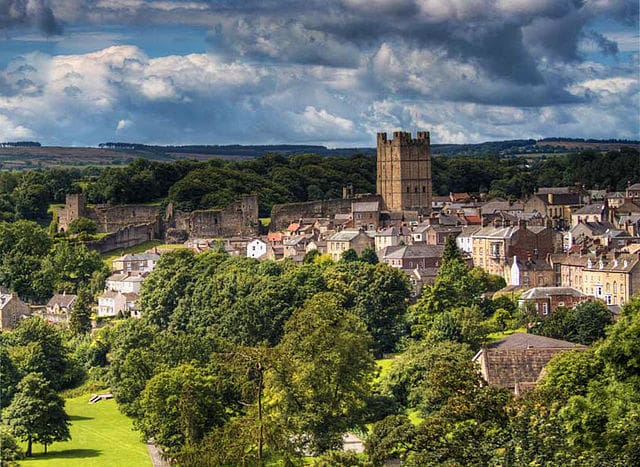
Wikimedia Commons by: Roberto1145
Day 10: Richmond to Osmotherley – 24 miles / 39km: After refueling in Richmond with you have the longest day ahead of you but it is relatively flat and easy underfoot. Some people choose to take it easy and split this day in two more leisurely hikes but most will do it in a day. By this point in the walk, your legs will have gotten into the rhythm of walking all day and will feel stronger than when you started. I say this to reassure people that 24 miles isn’t that bad with the proper footwear. If you are camping you can choose to stop before getting to Osmotherley or treat yourself to a bed and breakfast.
Day 11: Osmotherley to Blakey – 21 miles / 34km: While this section isn’t as far as the previous day, it feels like a long slog as a large chunk of it is walking along an abandoned train line. The highlight of this day is that at the end of the very long and flat track you emerge at the lonesome Lion Inn pub. In the absolute middle of nowhere, this amazing free house has rooms, campsite facilities, and some of the biggest portions of food you will see on the whole trail.
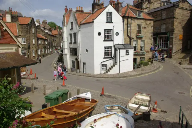
Day 12: Blakey to Egton – 10 miles / 16km: After sleeping off your meal from the night before you set off across desolate moorland which is breathtaking if you are walking while the heather is flowering. Look out for rare ground-nesting birds as you make your way towards Egton Bridge. If you want to resupply then do it in Glaisdale just before Egton as there are no shops in Egton Bridge, just bed and breakfasts.
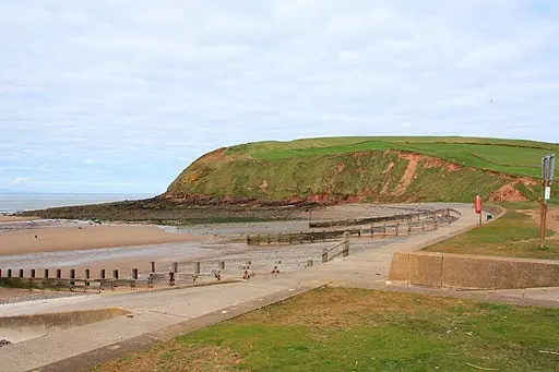
Day 13: Egton to Robin Hood’s Bay – 16 miles / 25.7km: At this point, you may either be happy that the end is in sight or sad that tomorrow you won’t have a hiking itinerary and will likely be returning back to normal life. There is a lovely stop at a waterfall cafe which can be cut out if you are desperate to get to the coast and don’t mind skipping a few miles. As you leave the wide-open moorlands you will soon spot the ocean and head down into the special town of Robin Hoods Bay. Here you can dip your toe in the ocean, throw your stone into the sea, and sign the Coast to Coast register in the pub by the dock. There are some great little cafes, restaurants and bars in this small but lively coastal village where you can treat yourself to completing the walk.
Geograph.org.uk by: Stephen McKay
Overall Thoughts: The British Coast to Coast is a wonderful way to experience the Great British countryside in 3 of the best national parks in the country. You can immerse yourself in small village culture along the way and get a basic understanding of the Yorkshire way of life. You will need to plan your trip in advance if you plan to stay in accommodation and know where you can get more water and food. I would recommend camping in campsites and in the wild but to be respectable and not have campfires without permission.
Accommodation Options
There are bed and breakfast facilities at every stop on the above itinerary but you will have to book in advance as they are very popular. There are also hostels and campsites at most places too if you like to get a shower and use a proper toilet. For the people who like to wild camp then there are plenty of places to pitch up out of the way if you pack up and get an early start before local dog walkers start to raise suspicion. Always follow the leave no trace rule and avoid lighting campfires unless you have permission.
Travel to and from the Coast to Coast
There is a train station at St. Bees which is the best option when traveling from anywhere in the UK. The station is right on the beachfront and there are 2 shops to buy last-minute supplies and a cafe for some warm food. On the other end in Robin Hoods Bay, you can catch a bus into Whitby where you can catch the Coastliner bus to York or Leeds. From here you can catch a train or MegaBus to anywhere in the UK.
Conclusion
Get planning and go walk the British Coast to Coast, you won’t regret it!
*******************************
This post was written and shared by Andrew Nicholls, Gear Assistant